St. Croix 360

River stories to inspire stewardship.

  • Share News
  • Event Calendar
  • About
    • Contact
    • Subscribe
  • Support

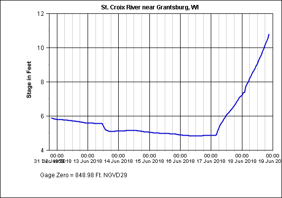
Evening flood update: Dam blows, bridges and roads out

By Greg Seitz | June 18, 2018 | 2 minute read

  • Facebook
  • Twitter
  • Email
  • Print
  • More
  • LinkedIn
  • Tumblr
  • Pocket
  • Telegram

9 p.m. update to today’s lead story: High water on the St. Croix after headwaters hit by torrential rain, flash flooding.

Dam destroyed

Radigan Dam on the Upper Tamarack River, which authorities warned was ready to fail earlier today, has met the prediction. The contents of the lake formerly behind the dam are now headed downstream several miles to the St. Croix.

A flash flood warning is in effect, with all bridges across the Upper Tamarack below Radigan Dam closed.

There are numerous cabins and properties along the stretch, and we wish them good fortune.

3:30 PM: THE RADIGAN FLOWAGE DAM ON THE TAMARACK RIVER HAS LIKELY BROKEN! FLOODING IS OCCURING! #WIWX pic.twitter.com/itiYTOvaSw

— NWS Duluth (@NWSduluth) June 18, 2018

DAM HAS LIKELY BROKEN! WATER NOW OVER ALL BRIDGES DOWNSTREAM IN SW DOUGLAS COUNTY! AVOID THIS AREA! #WIwx https://t.co/feaYkkLn7a

— NWS Duluth (@NWSduluth) June 18, 2018

Radigan Dam breaks…this is what other roads along the MN -WI borders look like… pic.twitter.com/hVg27qM78S

— Beth McDonough (@bmcdonoughkstp) June 19, 2018

Hinckley-Danbury bridge submerged, closed

Highway 48, which crosses the St. Croix at an access point called Thayer’s Landing, was closed this afternoon after water overcame the bridge deck.

MPR News photographer Andrew Krueger posted photos and videos on Twitter:

Highway 77/48 just closed at the St. Croix River bridge west of Danbury #Wisconsin. This is on the #Minnesota side, just west of the bridge #mnwx #wiwx @MPRnews pic.twitter.com/sRq2Rg5iI1

— Andrew Krueger (@akpix) June 18, 2018

Highway 77/48 closed at St. Croix River Bridge west of Danbury #Wisconsin. This is taken from the MN side looking toward WI at 3:50 pm pic.twitter.com/eviY33LKE1

— Andrew Krueger (@akpix) June 18, 2018

Rushing waters of St. Croix River lapping at bottom of road deck shortly before Highway 77-48 bridge west of Danbury #Wisconsin was closed this afternoon pic.twitter.com/DzSZYGnEqn

— Andrew Krueger (@akpix) June 18, 2018

Water continues to slowly rise over #Minnesota Highway 48 at the St. Croix River east of Hinckley. This taken at 4:55 pm. Road is closed; highway worker going to secure barricades pic.twitter.com/FJgOqYUBNd

— Andrew Krueger (@akpix) June 18, 2018

St. Croix floodwaters are covering Highway 48 and barricades are up… this truck was not too concerned pic.twitter.com/z9zRxo3fId

— Andrew Krueger (@akpix) June 18, 2018

Still rising

Water level gages have shot up in the past 24 hours, and show no sign of leveling off:

The Danbury gage has not updated since 9:30 last night (June 17):

Near Grantsburg

Forecast

Stillwater is still headed for pretty high water by this weekend:

From National Weather Service

Related articles:

Follow

  • Email
  • Facebook
  • RSS
  • Twitter

Features

Two inches and 6,000 gallons: A swollen century on the St. Croix River

Cold comfort

New preserve will let students, community, and anglers experience the Kinnickinnic River

St. Croix 360 is now 100% supported by readers.

Click here to contribute →


Latest News

St. Croix watershed in the spotlight during Wisconsin Water Week

Progress reported on effort to establish National Heritage Area for St. Croix River region

Afton State Park Phenology Feb. 19 to March 4, 2021

Spring is coming: Officials provide first St. Croix River flood forecast of season

Tax dollars work for water: Legacy Amendment funds will help protect St. Croix River

Privacy & Cookies: This site uses cookies. By continuing to use this website, you agree to their use.
To find out more, including how to control cookies, see here: Cookie Policy

About

St. Croix 360 builds support for river stewardship, and connects people and organizations. It is an independent news source produced by Greg Seitz, with past support from the St. Croix River Association.

Donate to St. Croix 360 today »

Story of 360

One of the biggest challenges facing the St. Croix River is harmful blooms of algae in in the lower river, due to excess nutrients in runoff. The goal is to restore the river by reducing phosphorus levels to 360 tons/year. Learn more »

Share Your News

St. Croix 360 is powered by a broad community of St. Croix River-loving people. Please visit our submission page to send tips, press releases, and other news.

Submit an Event

Lower St. Croix: St. Croix 360 partners with online calendar St. Croix Splash.

  • Submit your events to Splash.
  • Share it with St. Croix 360 for promotion.

For events elsewhere in the watershed, contact St. Croix 360 directly.

St. Croix 360 Syndication

To help increase awareness of the St. Croix River, news organizations and other outlets are free to share St. Croix 360 content, as long as you follow a few simple rules.

Republish St. Croix 360 stories »

Partners

  • St. Croix River Association
  • St. Croix Watershed Research Station
  • ArtReach St. Croix
  • You and all St. Croix 360's readers!
Handcrafted in May Township, Minnesota. Please contribute today »
loading Cancel
Post was not sent - check your email addresses!
Email check failed, please try again
Sorry, your blog cannot share posts by email.