


The below forecast concerns the entire upper Mississippi River basin, which includes the St. Croix. While the forecast is still worrying, the flood risk for the St. Croix has improved since the previous forecast in February.
As illustrated in the graphics above, there is now only about a 20 percent risk of ‘major flooding’ in Stillwater, compared to 50 percent two weeks ago.
Via the National Weather Service:
Overall, the flood risk for this drainage area including its tributaries continues to be well above normal.
Nearly 5 to 25% of normal precipitation fell across the Upper Mississippi River basin since the latest update to the Spring Flood Outlook. Mid-western Minnesota was the driest area with only 1 to 2% of normal precipitation. All across Iowa, southern Wisconsin, southern Minnesota and northern Illinois saw well below normal precipitation. As far as temperatures go, most of the area was 2 to 3 degrees above normal across Minnesota, Wisconsin, northern Iowa and northern Illinois. Northern Indiana was just above normal in this timeframe.
[su_button url=”https://www.stcroix360.com/support/” size=”7″ center=”yes” radius=”5″ icon=”icon: lock”]Please support St. Croix 360 →[/su_button]
These above normal temperatures have brought on the spring melt. Widespread melt has occurred and is continuing. Soils remain saturated, but with minimal frozen ground conditions, some areas have been able to absorb this snow melt. Ponding is continuing, and low lying areas are filling with melt water. Streams are seeing rises and iced areas are breaking up with some break up ice jams causing flooding.
Current snow cover extends across central Minnesota to central Wisconsin. Hutchinson, MN and Marshfield, WI appears to be the southern extent of the snow line. The average depth is about 6 to 8 inches with deeper amounts in the Peninsula and northern Wisconsin areas where depths of 18 inches and greater are common. This continues to be near to above normal for this time of year.
Water content in the snow in the Mississippi River contributing portions of Minnesota and Wisconsin is 2 to 5 inches on average. A recent report of 1.5 to 2 inches of liquid equivalent was reported across south central WI and in the north central parts of WI, reports of 2 to 5 inches have prevailed. Across central MN, liquid equivalents ranged in the 2 to 3.5 inch range. Overall the amount of snow water content remains to be above normal in the northern regions of the Upper Mississippi drainage area.
Soil moisture conditions as reported from the Climate Prediction Center continue to be well above normal across Minnesota and Wisconsin which are mostly in the 95th percentile. Iowa and northern Illinois soil profiles remain wet, but are slowly drying out and are in the 80 to 90th percentile for soil moisture. Northern Missouri ranks in the 70th percentile and is showing a drying out as well. Again, with dryness prevailing, the southern portion of the Upper Mississippi River basin is drying out. As we see soils dry out especially in the northern part of the basin, melt water and ponded water will be able to be absorbed, lessening the flood risk.
Monthly average streamflows across the Upper Mississippi River basin remain above to much above normal with many stations in the “high” category according to the U.S. Geological Survey. These stations are located mostly within Minnesota, Wisconsin and northern Iowa. “High” indicates that the estimated streamflow is the highest value ever measured for that day of the year. Frost depths within the drainage remain to be near to below normal.
Current warm temperatures and snow melt have created a few break up ice jam flooding situations, primarily in Minnesota on the Cottonwood, Minnesota and Rush Rivers. The Cottonwood River near New Ulm broke its banks on March 4th going into Major flood where it destroyed a nearby street.
Overall, the flood potential for the spring melt remains well above normal for the Upper Mississippi River drainage, especially on the mainstem rivers. There is a 50% or greater chance of major flooding from Dubuque, IA along the Mississippi River down to Burlington, IA and a 50% or greater chance of moderate flooding from Keokuk, IA on down to St. Louis, MO. The major flood potential has decreased from St. Paul, MN to near La Crosse, WI since our last update.
We will continue to closely monitor observed and forecast weather conditions as we continue the spring snow melt season. Conditions over the next few weeks or so will be key in determining just how the flooding situation evolves.


 Creative Commons Attribution-ShareAlike
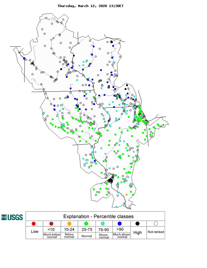